Some experts had written about Islam in America below … maybe just a fiction …
- –> http://www.fountainmagazine.com/Issue/detail/Islam-and-Muslims-in-America-before-Columbus
- –> http://www.sunnah.org/history/precolmb.htm
- –> http://www.themodernreligion.com/ht/before-columbus.html
- –> http://historynewsnetwork.org/article/23662
But afterward I realized that some cities in America use Arabic name …
A sum of 565 names, 484 in America and 81 in Canada, of villages, towns, cities, mountains, lakes, rivers and etcetera, are etymologically Arabic, designated by locals long before the arrival of Columbus. Many of these names are in fact the same as names of Islamic places; Mecca in Indiana, Medina in Idaho, Medina in New York, Medina and Hazen in North Dakota, Medina in Ohio, Medina in Tennessee, Medina in Texas, Medina and Arva in Ontario, Mahomet in Illinois and Mona in Utah, are just a few noticeable names at the outset. A closer analysis of the names of native tribes will immediately reveal their Arabic etymological ancestry; Anasazi, Apache, Arawak, Arikana, Chavin, Cherokee, Cree, Hohokam, Hupa, Hopi, Makkah, Mohician, Mohawk, Nazca, Zulu, and Zuni are only a few.
After 1-3 years I aware of that Arabic name city in America, finally it is easy to conclude that …
when first village/city settlement in America was found by Europe, they will use Europe name.
–> https://en.wikipedia.org/wiki/List_of_North_American_settlements_by_year_of_foundation
- 1610 Hampton, Virginia, United States
- 1611 Henricus, Virginia, United States
- 1622 Weymouth
- 1623 Dover New Hampshire
- 1623 Portsmouth New Hampshire
- 1623 Gloucester
- 1624 Burlington New Jersey
- 1624 Chelsea Massachusetts
- 1625 New Amsterdam New York
So when the arab came to America before Columbus …. They name the city use their Arabic language … as simple as that !
Where is the moslem of America before columbus gone?
All moslem were killed and annihilated by Christian just as Isabella and Ferdinand did to Moslem/Moors in Andalusia Spain in 1492. All killed and expelled out of Spain and Portugal in 16 – 17 century
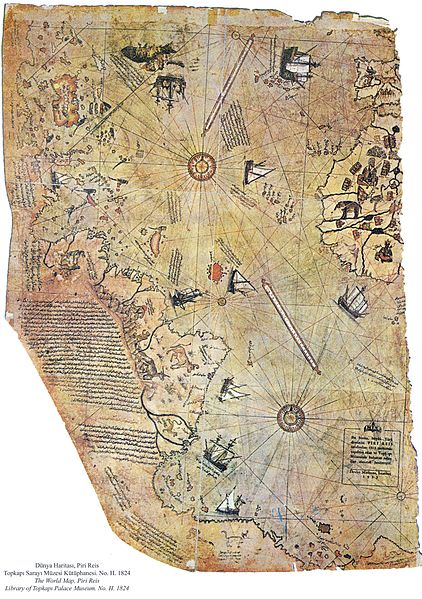
I have just found today article about Andes Mountain in 1513 map drawn by PIRI REIS (reis min admiral) Ottoman Admiral
In 1929, an amazing discovery was made in Istanbul, Turkey. A map drawn in the year 1513 by the Ottoman cartographer, Piri Reis was found. Reis wrote that his map was based on earlier sources, including ancient Greek and Arabic maps, including maps by Christopher Columbus, who had sailed only 21 years earlier. What is remarkable about this map is the level of detail of the map, which forced historians to re-evaluate the Columbus theory of exploration.
The Piri Reis map of 1513
The map clearly shows the eastern coast of South America, which is in the correct position with regards to Africa. The coast of Brazil is shown in incredible detail, with many rivers accurately placed on the map. Although Reis used Columbus’s maps as a source, Columbus never went to South America, so Reis must have gotten that from earlier Muslim maps that he used as sources. Furthermore, Reis’s map includes the Andes Mountains, which were not even explored by Europeans until the 1520s, a full decade after the drawing of Reis’s map!
Piri Reis based his map on earlier sources, which clearly had a very good understanding of the Americas and had explored the area well before the first Europeans. The map is perhaps the strongest physical evidence of Muslim exploration of the Americas before Columbus
Where the hell is Piri Reis got Andes information if Europeans did’nt know about andes mountain? Off ourse from the moors (Moslem of spain that In 1492 under Christian and in 16-17 all moslem have to convert or be killed) … …
- –> http://lostislamichistory.com/columbus-was-not-the-first-to-cross-the-atlantic/
- –> https://en.wikipedia.org/wiki/Piri_Reis
- –> https://en.wikipedia.org/wiki/Piri_Reis_map
- –> http://www.world-mysteries.com/sar_1.htm
- –> https://www.uwgb.edu/dutchs/pseudosc/piriries.htm
- —> https://www.saudiaramcoworld.com/issue/198001/piri.reis.and.the.hapgood.hypotheses.htm
- —> http://www.theepochtimes.com/n3/1165572-piri-reis-map-evidence-of-a-very-advanced-prehistoric-civilization/
- —> http://www.ancient-origins.net/antarctica-ancient-technology/piri-reis-map-evidence-ancient-technology-00276
- —> http://www.anomalies-unlimited.com/Piri_Reis_Map.html
